INVENTA Manuals
INVENTA provides three options for viewing the positions of your animals on a map.
Option 1: Use the Home Screen
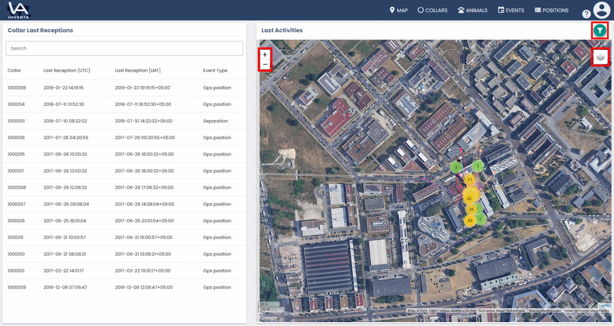
With this method you can check the latest position data of all your collars at once. To see more detailed position data please continue with option 2.
In the right area of the Home Screen you will find a map that shows the positions of all your registered collars by default.
To change the zoom factor, you can use the mouse wheel or the +/- buttons in the upper left corner of the map.
On the right above the map, you will find the filter button. Here you can select either a number of recent positions or a specific time span in days, weeks, months or years. The initial values of these filters can be set in your preferences.
If you move your mouse cursor over the –icon you can show or hide different view options. One of three map display types can be selected here. And you can decide whether many positions in a small space should be combined into a cluster and if tracks and/or track arrows should be displayed.

Option 2: Use the maps page
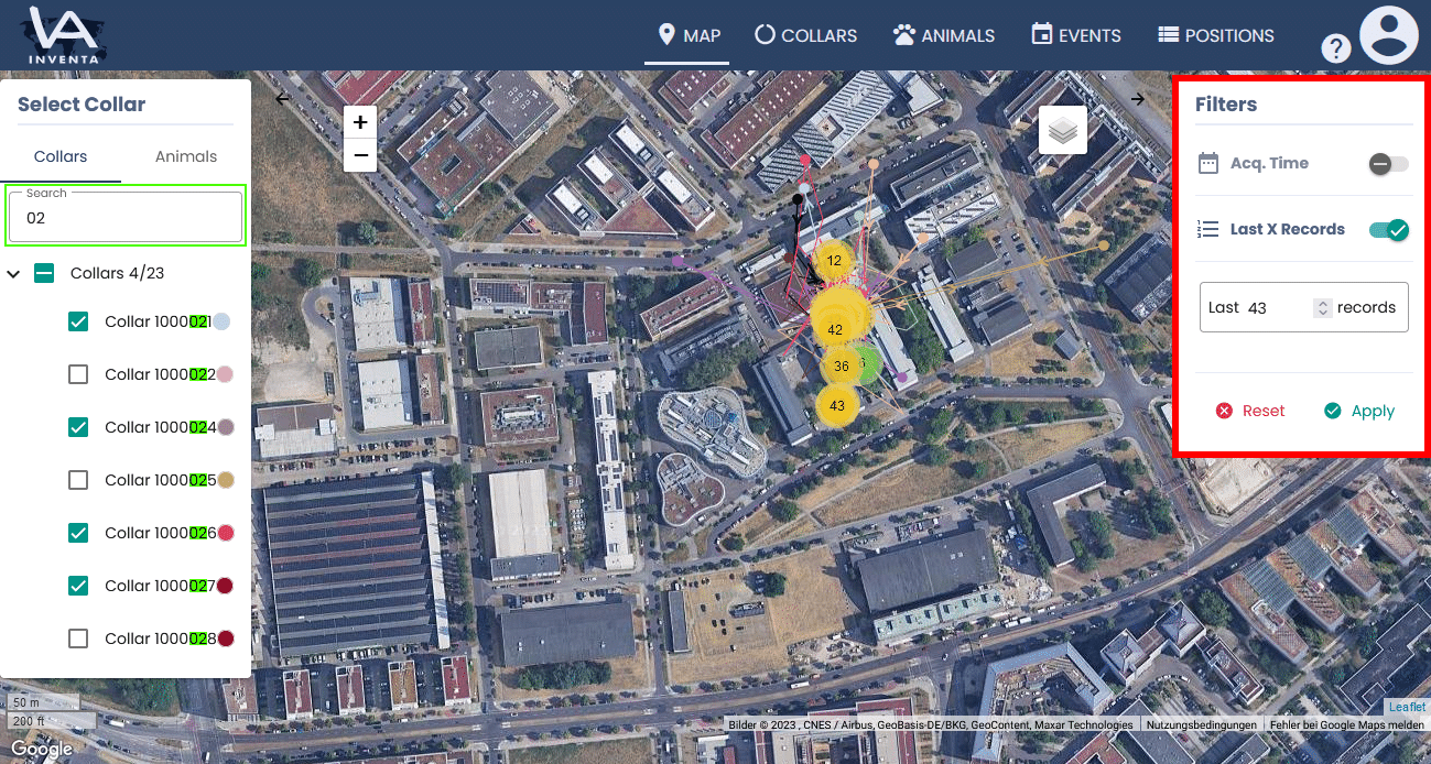
Just to the left of the map you can select the collars whose position should be displayed on the map. The search field allows you to show specific collars or in other words hide collars you do not want to view.
To the right of the map are the filters. Here you can select either a number of recent positions or a specific time span in days, weeks, months or years.

Option 3: Use the Collar properties
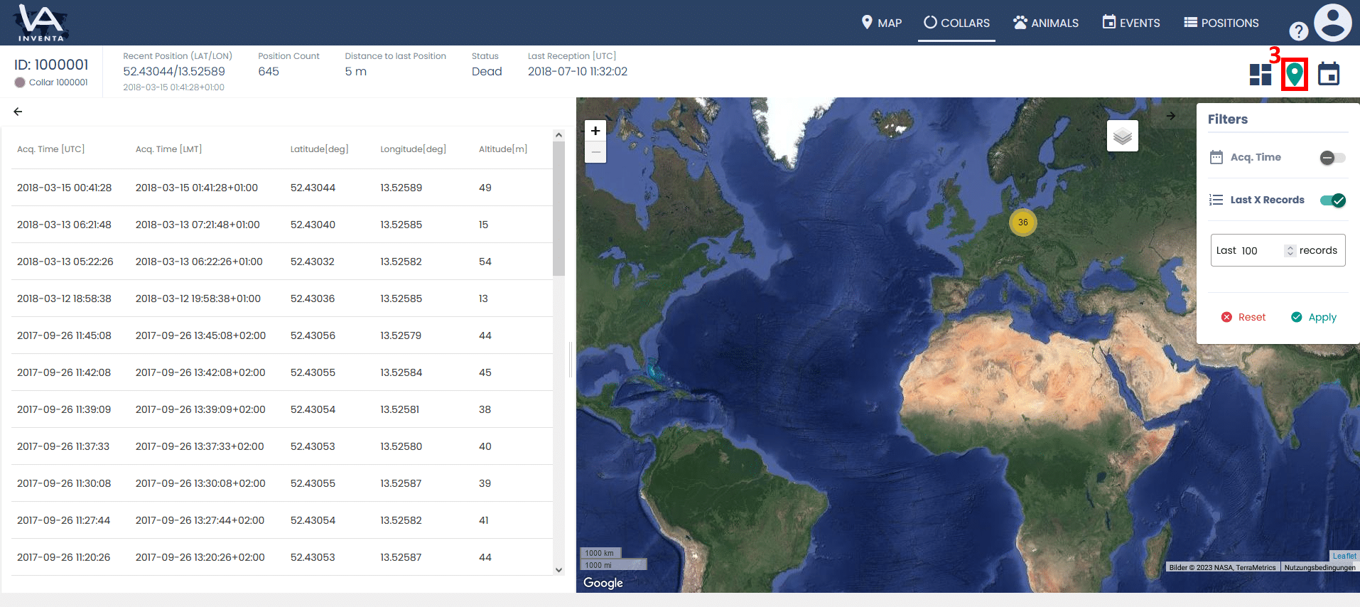
First go to the collars page and then click on the table row with the collar, and open its Collar Properties.
Then click on the map button in the upper right corner.
Here the positions of the collars are displayed according to the filter.


| Cookie | Duration | Description |
|---|---|---|
| cookielawinfo-checkbox-analytics | 11 months | This cookie is set by GDPR Cookie Consent plugin. The cookie is used to store the user consent for the cookies in the category "Analytics". |
| cookielawinfo-checkbox-functional | 11 months | The cookie is set by GDPR cookie consent to record the user consent for the cookies in the category "Functional". |
| cookielawinfo-checkbox-necessary | 11 months | This cookie is set by GDPR Cookie Consent plugin. The cookies is used to store the user consent for the cookies in the category "Necessary". |
| cookielawinfo-checkbox-others | 11 months | This cookie is set by GDPR Cookie Consent plugin. The cookie is used to store the user consent for the cookies in the category "Other. |
| cookielawinfo-checkbox-performance | 11 months | This cookie is set by GDPR Cookie Consent plugin. The cookie is used to store the user consent for the cookies in the category "Performance". |
| viewed_cookie_policy | 11 months | The cookie is set by the GDPR Cookie Consent plugin and is used to store whether or not user has consented to the use of cookies. It does not store any personal data. |